
Category:Digital elevation models
English: A DEM is a Digital Elevation Model (MNT, Modèle Numérique de Terrain in french), that is to say a numerical representation of the topography, which could be edit, viewed, and allows calculations and maps.
3D model of land elevation and features; for specific DSM or DTM use specific wikidata IDs   | |||||
| Upload media | |||||
| Subclass of |
| ||||
|---|---|---|---|---|---|
| Has use | |||||
| Has part(s) |
| ||||
| |||||
Subcategories
This category has the following 4 subcategories, out of 4 total.
D
Media in category "Digital elevation models"
The following 55 files are in this category, out of 55 total.
-
 2m DTM.jpg 5,960 × 4,472; 6.64 MB
-
 An Corran DEM.jpg 1,128 × 886; 350 KB
-
 Augmented Reality Sandbox tested in Greenland.jpg 2,160 × 3,840; 2.6 MB
-
 Chun-airsar-dem-orthophoto.jpg 800 × 578; 50 KB
-
 Continuo de Elevaciones Mexicano.jpg 1,039 × 764; 191 KB
-
 DEM DTM.png 2,000 × 461; 55 KB
-
 DEM NewZealand.png 3,120 × 2,462; 2.28 MB
-
.jpg/120px-DEM_of_Human_Footprints_(9338fb36-ad48-4e84-97f1-e46175c9f996).jpg) DEM of Human Footprints (9338fb36-ad48-4e84-97f1-e46175c9f996).jpg 1,653 × 916; 164 KB
DEM of Human Footprints (9338fb36-ad48-4e84-97f1-e46175c9f996).jpg 1,653 × 916; 164 KB
-
 Digital Elevation Model - Red Rocks Amphitheater, Colorado.jpg 482 × 368; 110 KB
-
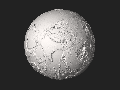
.png/120px-Digital_Elevation_Model_of_our_Earth_(5853060236).png) Digital Elevation Model of our Earth (5853060236).png 1,834 × 1,811; 4.38 MB
Digital Elevation Model of our Earth (5853060236).png 1,834 × 1,811; 4.38 MB
-
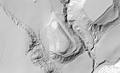
 Digital elevation model of small Himalayan glaciers - 50090950206.jpg 620 × 592; 434 KB
-
 Digital terrain model of Battle Mountain based on ASTER data.png 1,217 × 752; 217 KB
-
 Digitales Geländemodell.png 632 × 320; 24 KB
-
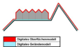 DOM DGM.png 833 × 469; 154 KB
-
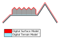 DTM DSM.svg 1,003 × 652; 8 KB
-
 Earth dry elevation 10x.stl 5,120 × 2,880; 22.2 MB
-
 Earth dry elevation 2.stl 5,120 × 2,880; 20.74 MB
-
 Earth dry elevation.png 2,160 × 1,080; 827 KB
-
 Earth dry elevation.stl 5,120 × 2,880; 27.66 MB
-
 El-Castillo-Mugeta.png 1,272 × 778; 952 KB
-
 Geo-Oberflaechen Grosse-Lauter-Stoerung Schwaebische Alb.jpg 2,338 × 1,520; 1.19 MB
-

-
 Global Digital Elevation Model.jpg 4,320 × 2,160; 1.08 MB
-
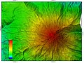
 High-resolution DEM of Mount St. Helens.jpg 4,238 × 6,330; 12.9 MB
-
 Højdemodel for området omkring Rønde på det sydlige Djursland.jpg 3,308 × 3,262; 2.14 MB
-
.png/120px-JDem846_Screenshot_-_Model_Setup_(6956641073).png) JDem846 Screenshot - Model Setup (6956641073).png 1,153 × 761; 124 KB
JDem846 Screenshot - Model Setup (6956641073).png 1,153 × 761; 124 KB
-
 Luna en proyección ortográfica.jpg 8,584 × 4,924; 12.49 MB
-
 Mars elevation 2.stl 5,120 × 2,880; 20.74 MB
-
 Mars elevation.stl 5,120 × 2,880; 27.93 MB
-
 Maxbe vomper loch aster.png 900 × 675; 519 KB
-
 Maxbe vomper loch opendem.png 900 × 675; 520 KB
-
 MNT MNE.svg 438 × 101; 76 KB
-
 Modelo 3D de Gran Canaria Islas Canarias.stl 5,120 × 2,880; 102.58 MB
-
 Modelo 3D de la Isla Atlasov.stl 5,120 × 2,880; 85.8 MB
-
 Modelo 3D de São Miguel Islas Azores.stl 5,120 × 2,880; 105.77 MB
-
 Modelo 3D de Tenerife, Islas Canarias.stl 5,120 × 2,880; 198.17 MB
-
 Modelo 3D del Aconcagua.stl 5,120 × 2,880; 323.83 MB
-
 Modelo 3D del Ama Dablam.stl 5,120 × 2,880; 129.15 MB
-
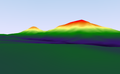
 Montserrat aster 3D.png 563 × 653; 115 KB
-
 Moon elevation 2.stl 5,120 × 2,880; 20.74 MB
-
 Moon elevation.stl 5,120 × 2,880; 25.07 MB
-
 Mountain Elevation Comparison.png 10,300 × 500; 3.83 MB
-
 Mtm-05277e 3d.png 1,274 × 972; 522 KB
-
 Nile delta elevation cross-section 01.gif 730 × 730; 51 KB
-
 Nile delta elevation cross-section 02.gif 730 × 730; 49 KB
-
 Penang island.stl 5,120 × 2,880; 2.54 MB
-
 Penang south Kedah heightmap ASTGTM2 N05E100 dem.png 3,601 × 3,601; 8.41 MB
-
 Ruimtelijk model.JPG 2,435 × 1,799; 1.32 MB
-
 Simple Digital terrain model.gif 726 × 532; 28 KB
-
 SRTM SIR-C vs X-SAR.png 1,616 × 942; 522 KB
-
 Srtm voidfilling grass gis.png 1,256 × 452; 714 KB
-
 SRTM X-SAR Coverage.jpg 1,200 × 1,089; 161 KB
-
 SRTM30.png 1,065 × 664; 891 KB
-
_and_Digital_Terrain_Models_(DTM)_when_talking_about_Digital_Elevation_models_(DEM).svg/120px-The_difference_between_Digital_Surface_Model_(DSM)_and_Digital_Terrain_Models_(DTM)_when_talking_about_Digital_Elevation_models_(DEM).svg.png)
-
 Wassermühlen am Wehebach.png 2,952 × 1,771; 3.44 MB


.jpg)

.png)


.png)


_and_Digital_Terrain_Models_(DTM)_when_talking_about_Digital_Elevation_models_(DEM).svg)